
Walking is a wonderful pastime, but however much we ramblers enthuse about it, we have to admit that it does lack one ingredient.
There is no frisson of danger.
Rock-climbing, paragliding, even horse-riding, can get you killed with the greatest of ease. All an English country footpath is likely to deliver is the odd bramble scratch.
There is one exception to this rule.
It is a three-mile Essex track named the Broomway, lying on the Maplin Sands, about 300 yards off the shore of Foulness Island.
Edwardian popular newspapers dubbed the Broomway "The most perilous byway in England", and "The Doomway". Excited hacks regaled readers with lurid tales of the many persons who had ventured on to this legend-strewn track and never been heard of again.
It was the stuff of Victorian melodrama, but there was something else exceptional about the Broomway. The grim tales were all true.
This killer path is still a thing of mystery, despite decades of research by archaeologists and historians.
We know it is ancient, but unlike things made of wood or stone, it is not possible to date it exactly.
The venerable trackway may well predate the Romans.
But who created it, or discovered it, and how has it defied the pounding and scouring of the Maplin surf for hundreds, maybe thousands, of years?
The only parallel to the Broomway phenomenon in Britain is the far more famous Morecambe Bay walk, off the coast of Lancashire.
Here, as with the Broomway, the walker has to take account of fast tides and quicksands.
The difference is that the route across Morecambe Bay is constantly shifting. Not the least remarkable aspect of the Broomway is that it is a rigid, unchanging right of way.
For some reason there is a tough if narrow, base supporting the Broomway, so solid that even the force of the North Sea, patiently attacking it century after century, hasn't shifted it an inch.
Local guide Patrick Arnold has studied the track for decades, yet he has no satisfactory explanation for this miracle of natural - or could it be man-made? - engineering.
The local historian Arthur Woodward believes there is a natural outcrop of chalk below the surface.
If so, this sliver-thin, ruler-straight phenomenon is a true gift of the geological gods.
Whatever its origins, the Broomway has been an integral part of life on Foulness Island since men first settled there.
The first written account is in the manorial records of 1419, but the Broomway had already been there "since time whereof the memory of man runneth not to the contrary".
Local farmers, though, weren't concerned with the track's heritage status. To them, it was an invaluable line of communication with the mainland.
Foulness Island is pierced by numerous creeks, many of which were only finally bridged in the 20th century.
Before this happened, the creeks presented a time-consuming and sometimes dangerous obstacle to anyone taking a wheeled vehicle off the island.
By contrast, the Broomway at low tide was a veritable super-highway.
It was solid, reliable and speedy and the surface needed no maintenance.
Equally to be relied on was the fact that the Broomway would kill you, if you failed to get the tide times right, or strayed off the narrow way into the soft mud and sand.
Local people knew these rules and respected them, but even they risked a third, wild-card danger. This was the sea-mist, which could, seemingly from nowhere, suddenly swirl across the path, blanking out all vision.
To guide travellers, local people resorted to a unique device.
On either side of the Broomway, at 30 yard intervals, they drove stakes.
To these stakes they tied bundles of twigs, giving the appearance of a witch's broom, or besom.
The besoms gave the Broomway its name.
The brooms have gone, but the path through the sea remains, unchanging and implacable as ever.
It is still clearly marked and defined as a right of way on Ordnance Survey maps.
Legally, a walker can stroll along the Broomway as he chooses. Yet for many years the route has been subject to a conspiracy of silence.
Few people even know of its existence.
Ramblers' groups, only too willing to fight for the right to roam elsewhere, have steered shy of the Broomway, not wishing to see their members drown in droves.
I have rambled and written about other footpaths of Essex, but never ventured so much as a toe onto the most fascinating walk of them all.
As if it wasn't already myth-shrouded enough, the Broomway has had another veil of mystery and impenetrability cast over it, thanks to the secret military operations of Foulness Island.
If the sea or the mud don't get you, the spooks will.
So all I've ever dared do was stand on the shore and stare out at the mystery path.
Not that there's anything to see.
Once you would look out for an avenue of brooms.
Now, without these markers, the Broomway just blends into the rest of the Maplin Sands as they stretch to the horizon.
It's hardly surprising that the Broomway has remained so obscure. But like other secrets of the seabed, it's there all right, even if you can't see it.
Now suddenly things are changing. The Broomway is set to emerge from its long slumber.
The initiative for this resurrection has come from Essex County Council.
Christine Allman, Essex County Council's public rights of way engineer, explained: "We're working to encourage more use of our public footpaths and we can't get away from the fact that the Broomway is part of the system.
"But if people are going to use it, we want them to be aware of what they are taking on."
There is another factor that is helping to bring the Broomway alive again, and his name is Patrick Arnold.
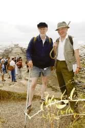
Patrick, a retired carpenter and form-maker, was born and raised on Foulness and has spent a lifetime exploring and roaming the estuary.
He knows the Broomway intimately and still walks it at regular intervals, always barefoot.
Patrick also holds an official record for rowing single-handed from London to Ostend.
If the Broomway is a piece of living heritage, so is he.
Patrick carries a specially marked compass, but he relies chiefly on the his own knowledge of the shoreline to provide his bearings.
To most of us, the edge of Foulness looks fairly monotonous.
For Patrick, every yard of the shore's contour is a marker.
Patrick is now the council's key to opening up the Broomway.
"We want him to lead walking groups on the Broomway and we also want him to pass on his special knowledge to other people, so they can be guides as well," says Christine Allman.
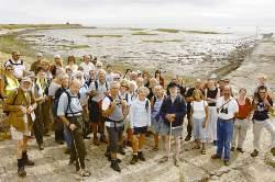
So it was that on a warm, still Sunday last month, the ancient road once again encountered something it may not have known for a century or more, the sensation of mass human footfall.
The official Broomway walk had been organised by Essex County Council, with the co-operation of the Ministry of Defence and QinetiQ, which operates the weapons testing base.
Around 30 people turned up, mostly comprising councillors, council officials, such as highway officers, and representatives of local rambling groups.
Everyone was out to enjoy themselves, but there was also a slight air of nervousness. "It's got a murderous reputation, which I suppose makes it that much more exciting," said Janet Bate, who had driven down for the occasion from Colchester.
The organisers knew they were taking on a formidable proposition in the Broomway. "We don't want headlines reading Council Walking Party Lost at Sea'," said county councillor Tracey Chapman.
But even the Broomway had to respect the display of local government efficiency on display.
Leading the way, was the feisty figure of Patrick Arnold.
Alert council officers flanked the party on either side, with others acting as tail-end charlies.
"We are determined not to lose anybody," said Christine Allman. We had all placed our trust in Patrick, but just to be sure, Christine had packed a hidden weapon, one that might have saved quite a few lives in the past - a global positioning device.
Yet the Broomway had one last surprise in store. It turned out to be a pussycat.
The sand and the trickle of seawater that still covered it were warm underneath. The views over Foulness and across the mouth of the Thames Estuary were captivating.
The three miles between Wakering Steps and Asplin's Head flew by.
Nobody got swept away or wandered into a quicksand.
There must have been a note of surprise in my voice when I praised the Broomway's calmness and beauty to Patrick Arnold.
"But that's how it is," he said. "I keep coming back because of that, and that's why I want to share it. I respect the Broomway. It can still kill you, but if you know and understand it, it becomes an old friend."


Comments: Our rules
We want our comments to be a lively and valuable part of our community - a place where readers can debate and engage with the most important local issues. The ability to comment on our stories is a privilege, not a right, however, and that privilege may be withdrawn if it is abused or misused.
Please report any comments that break our rules.
Read the rules hereComments are closed on this article